Physical Address
304 North Cardinal St.
Dorchester Center, MA 02124
Physical Address
304 North Cardinal St.
Dorchester Center, MA 02124
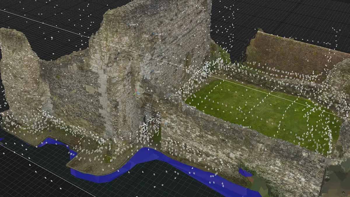
This article will introduce and guide you through the principles, technologies and workflows involved in photogrammetry, allowing you to create 3D models from a few photos.
Photogrammetry is a methodological process used to reconstruct the geometric properties of physical environments or discrete objects from photographic imagery. By analyzing a sequence of overlapping photographs taken from multiple perspectives, advanced computational algorithms calculate three-dimensional (3D) spatial data, resulting in highly detailed digital models and precise measurements. This technique, positioned at the intersection of optics, geometry, and computer vision, plays a critical role in numerous disciplines, including geospatial analysis, civil engineering, architecture, heritage conservation, industrial manufacturing, forensic documentation, and digital content creation for entertainment and simulation.
Photogrammetry represents the convergence of optical science, spatial computation, and digital imaging. As a flexible and continually advancing technology, it empowers users to recreate and analyze real-world environments in detailed digital form. From drone-based architectural documentation to micro-scale artifact preservation and asset creation, its applications are vast and growing.
With increasing computational capabilities, intuitive software, and broader hardware access, photogrammetry is more approachable than ever. Paired with complementary technologies such as LiDAR and machine learning, it is evolving into a critical component of modern documentation, visualization, and analysis workflows.
Historically, photogrammetry emerged in the 19th century for topographic mapping and aerial reconnaissance. Nonetheless, today digital processing and automation have transformed it into a scalable and accessible tool with a broad spectrum of applications. As with a lot of new technologies, it was first used in warfare in order to get information about the enemy’s fortifications.
While in the past photogrammetry was used for just surveying lands and big buildings, in the present photogrammetry became more than a scanning method, it became a dynamic bridge between the physical and digital worlds, enabling exploration, insight, and innovation (and I don’t even need to mention that it helps you create 3D models in a really small fraction of the time it’d traditionally take to do it, which is the reason why most of us are interested in it!).
At the core of photogrammetry lies geometric triangulation. When a single physical feature is captured in at least two photographs taken from distinct spatial viewpoints, its 3D coordinates can be accurately resolved by analyzing the intersection of the sightlines extending from each camera position to the object. This technique, once labor-intensive, is now largely automated through Structure-from-Motion (SfM) pipelines. These algorithms not only estimate the position and orientation (extrinsics) of the cameras but also simultaneously recover the spatial arrangement of the photographed scene
Note: photogrammetry has a wide range of applications, but in this article we’ll mention the three most important applications: architectural phogrammetry, land surveying and 3D modeling from physical objects.
Architectural photogrammetry focuses on capturing the external and internal geometry of buildings, monuments, and structures using images acquired from ground-based or aerial platforms. Unlike land surveying, which emphasizes uniform terrain mapping, architectural photogrammetry requires varied and adaptive capture strategies based on the building’s size, complexity, and occlusions. Techniques may include manual camera walkthroughs, oblique aerial shots using UAVs, and close-range scans for façades or ornamentation. Outputs include detailed 3D models, elevation drawings, and textured surfaces suitable for restoration, documentation, and digital archiving.
Key Benefits:
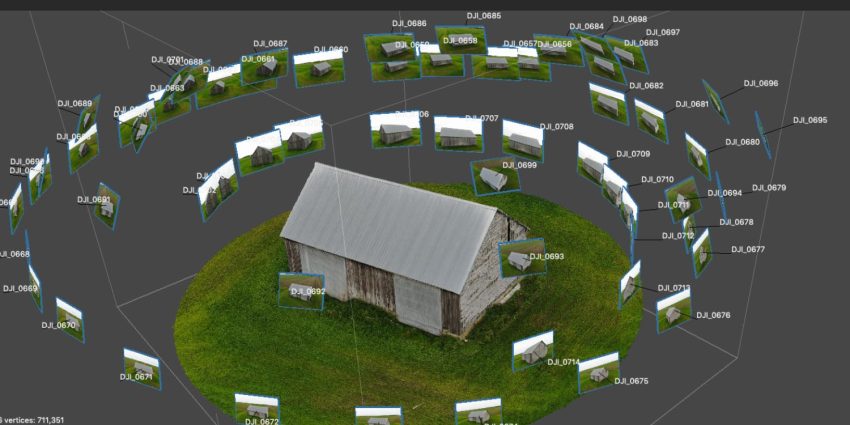
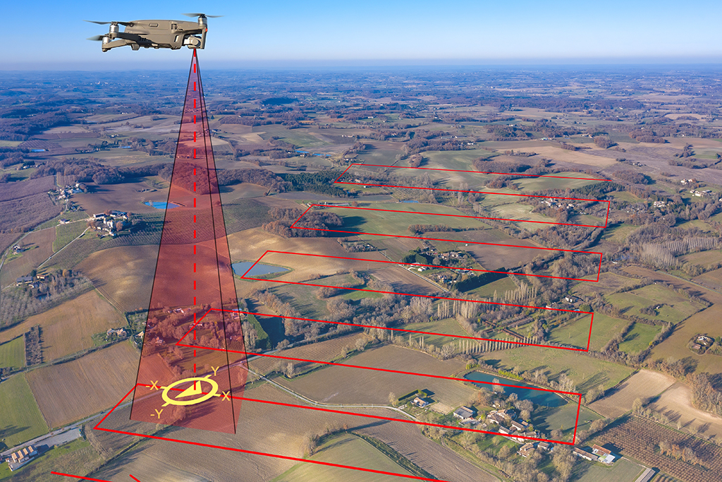
Land surveying photogrammetry typically involves aerial image acquisition using UAVs in systematic grid or double-grid flight patterns to ensure consistent coverage and accurate terrain modeling. This approach is optimized for generating Digital Elevation Models (DEMs), orthophotos, contour maps, and volumetric measurements for land management, construction, agriculture, and environmental monitoring. The workflow emphasizes georeferencing with high-precision GNSS data, ground control points (GCPs), and post-processing in GIS-compatible formats for integration into planning and development systems.
Key Benefits:
Photogrammetry is specially useful as a Data Layer in Geographic Information Systems (GIS) and Deep Mapping (rich-data mapping system which cross-correlate multiple data sources in order to understand the context, patterns, inner workings, history and evolution of a city). For more in-depth articles about GIS and Deep Mapping see the following articles:
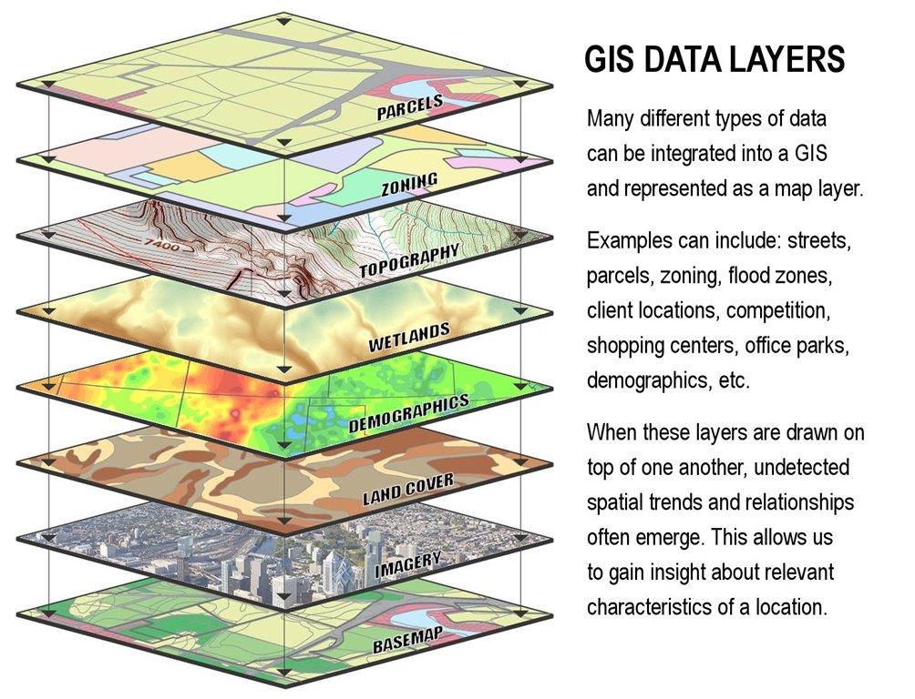
In modern GIS techniques (that’s kinda a redundancy since GIS is a very modern technique all by itself) photogrammetry can be one of the most valuable Data Layers in the geographic model we’re building.
Photogrammetry is equally powerful at micro scales. It is widely used to digitize small- to medium-sized objects with high precision and texture fidelity. Applications include documentation of cultural heritage artifacts, manufacturing quality control, and generation of assets for computer graphics pipelines.
When you’re creating 3D models of physical objects, photogrammetry consists in taking several photos from as many angles as possible. Then your photogrammetry software will use all the positional information in your photos meta data, and use the image data and the positional information to automatically build the 3D model.

The previous image you’re seeing is the photogrammetry software showing you all the angles from where photos of that statue were taken. The software does this automatically.
Visual Asset Applications:
Professional studios will not use a single camera, instead, they have multi camera rigs, and these rigs take dozens of photos at the same time, allowing the studio to create life-like 3D models of actual, living people. Hideo Kojima‘s studio utilizes that method regularly.
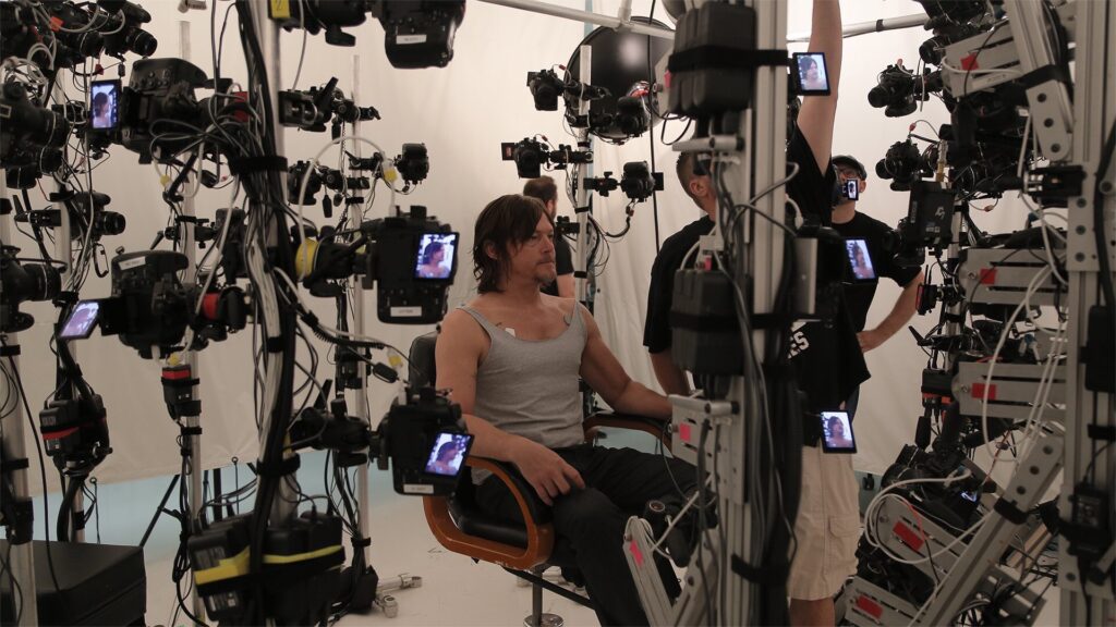
Of course you don’t need such a setup if you’re scanning static things. A single camera and enough patience are more than enough.
Industrial and Scientific Use Cases: